


The challenge of planning a mobile network has never been easy, but it’s certainly fair to say that 5G has made it a whole lot more complicated for RF engineers. New technologies like massive MIMO and beamforming have to be planned for. Multiple new spectrum bands, from high-frequency mmWave to low bands have to be accommodated in a nationwide 5G network spanning dense urban areas and rural expanses, and serving diverse markets and use cases. And all this against a backdrop of ever-tighter budgets and shorter deadlines demanded by the business.
That’s why it is so crucial that your network planning decisions are data-driven.
What updates does Planet 7.9 provide to enhance RF planning?
In the latest release of Planet, Infovista’s industry-leading RF planning and optimization solution, we’re making data-driven 5G network planning easier, more accurate and more dynamic. Planet 7.9 brings the full potential of AI-powered network planning with new datasets, modeling capabilities and user-friendly tools so you can be confident that your network designs will deliver the performance KPIs and business-outcomes that define success.
Let’s take a look at how Planet 7.9 uses crowdsourced data KPI analysis, tree canopy and bridge modeling, and user-friendly analysis tools to help you make better 5G RAN planning decisions.
Crowdsourced data analysis
RAN engineers need to be able to make informed network planning decisions based on the most accurate and comprehensive network performance data available. This means being able to understand not only network KPIs, but how network performance varies hour-by-hour and day-to-day.
That’s why crowdsourced data is so valuable to the network planning process. Only by having a detailed picture of traffic demand and network KPIs based on 5 billion data points collected daily worldwide can you understand how subscribers are using and experiencing your services and derive the actionable insights that will transform your 5G network planning and tuning.
Direct umlaut database integration
Planet 7.9 is directly integrated with Accenture’s umlaut crowdsourced data database. This unique integration means operators can monitor network performance KPIs, such as throughput on the 4G network versus the throughput of the new 5G network, and make informed planning decisions on future network coverage and capacity.
We know how valuable this crowdsourced data is to accurate 5G network planning decision-making. In Planet 7.5 we gave RF planners the ability to use the umlaut crowdsourced data to generate traffic maps on which to base their RF planning.
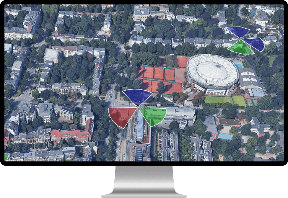
KPI layers in Planet’s Network Analysis module
We’ve gone further in Planet 7.9, with users now able to generate crowdsourced data KPI layers in Planet’s Network Analysis module. Taking 5G as an example, RF planners can view heatmaps for KPIs such as downlink or uplink average data rate, SS-RSRP and SS-RSRQ. They can further filter these maps by date ranges as well as specific days of the week and hours of the day. KPI heatmaps can also be filtered on specific carriers and specific mobile network codes.

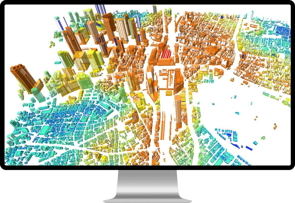
New: Vegetation canopy and bridge modeling for better design analysis
To deliver highly reliable network plans you need to be able to ensure your radio networks perform as intended when built. That’s why in Planet 7.9 we’re further improving network design analysis by extending the modeling capabilities. An important part of this is AIM, Planet’s AI-powered 3D propagation model. The latest version – AIM 3.0 – has been released alongside Planet 7.9 and greatly simplifies the way your networks can be planned, drastically reducing the operating costs related to calibration while improving the accuracy and reliability of RF simulations and wireless coverage predictions.
Canopy modeling
AIM can now model trees with more accuracy, by considering the trunk height and the canopy height when calculating propagation losses. This is particularly significant for the accurate prediction of picocell and small cell coverage in situations where these cells and their users are both below the tree canopy. AIM can also provide simulations for when trees are in-leaf and out-of-leaf allowing users to analyze both summer and winter coverage.

Suspended structure modeling
AIM can now model suspended structures such bridges and mezzanine floors with more accuracy. This includes modeling suspended structures in the diffraction algorithm as well as the ability to model coverage on top of a suspended structure and below it.
Additional vegetation modeling methods
Additional vegetation modeling methods have been added to AIM (and the Planet P3M model). These include:
- ITU-R, Cost 235 (in-leaf and out-of-leaf),
- FITU-R (in-leaf and out-of-leaf)
- Linear loss, allowing engineers to use their preferred approach.
Multiple vegetation types are also now supported in the same path profile.
New AI datasets
AIM 3.0 includes new pre-calibration and AI training datasets including:
- Improved rural datasets,
- Optimized near-field datasets
- Improved ray launching vs. non ray launching metrics.
Improved network analysis and visualizations
Planet 7.9 also improves network analysis in a number of areas including the ability to extract 2D statistics from 3D analysis for slice analysis at specific heights, network analysis template color profiles to enable map updates at the click of a button and improved Google Earth and ESRI exports for network analysis outside of Planet.
Key highlights include:
Google Earth export improvement
The export to Google Earth now includes the Planet active sector display scheme. This means the sector pies displayed in Google Earth will have the same coloring and display properties as they had in Planet. Multiple sectors can now also be shown in a segment. Google Earth exports now also include a tree structure browser for all the sites in the KMZ file.
Network analysis template color profiles
Color profiles can now be configured within Network Analysis templates. This means with a right-click a user can change the colors displayed on a map. For example, one template suited to detailed analysis might have a gradient of colors from green to red. Another template suited to showing a higher-level view might only have 5 colors showing where signal is excellent, good, average, poor and very poor. Yet another template might only have two colors, one for where there is indoor coverage and one for where there is only outdoor coverage.
2D statistics from 3D analysis
It is now possible to run 2D statistical analysis for all layers directly from a 3D layer stack in the analysis tree. This means, not only can RF engineers understand the 3D network performance statistics for an area, but they can also understand the 2D statistics for slices at specific heights in that 3D area.
ESRI format exports
It is now possible to export network analysis data to ESRI ASCII and ESRI Shape files.
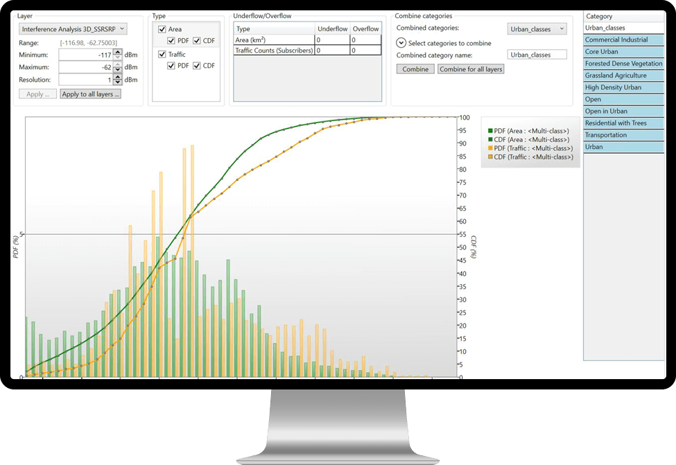
New advanced PDF/CDF tool
Planet 7.9 introduces a new and advanced PDF/CDF (probability density function / cumulative distribution function) tool. This upgrade enables ‘on-the-fly’ recalculation for multiple clutter class selections. Users can select multiple layers for analysis, visualize area and traffic simultaneously, and view PDF and CDF in the same graph window. Additionally, the PDF/CDF viewer allows for easy export of current graph information for a single layer or all layers to an Excel or csv file.
RAN technology enhancements
Planet already provides comprehensive support for RF planning of 2G – 5G technologies. For Planet 7.9, in a constant quest for improvements, we have managed to improve the way certain aspects of network modeling are handled.
SS-CINR layer handover gain modeling
A new setup allows for handover gains to be modeled as part of the SS-CINR layer to improve SS-CINR accuracy in cell handover locations.
New methods for master eNodeB mapping
New methods have been added for simplified mapping of master eNodeB in dual (NSA) LTE/NR workflows. These include the ability to use “any” LTE sector as master based on coverage criteria and the ability to use the top N LTE neighbors to define the master list.
Enhanced carrier support
Overlapping carriers with different bandwidths are now fully supported at the sector/cell/carrier level across all modules of Planet. Powers and frame configurations are now carrier specific and set at the carrier (not sector) level. The concept of a “main” carrier had been introduced for some workflows/global layers to simplify setup.
Don’t just take our word for it
Accurate mobile network planning can reduce a nationwide operator’s CAPEX by $2 billion over 10 years, according to industry research conducted by Mobile Experts. In the report, Joe Madden, founder and lead analyst at Mobile Experts said:
“RAN planning tools have evolved into RAN optimization solutions that use a continuous cycle to deliver maximum return on the CAPEX invested. RAN Planning has also become instrumental to improving quality of experience, which minimizes churn. AI/ML-based, data-driven prediction engines are becoming the de-facto standard to deliver the accuracy required and ensure the optimal network design is arrived at.”
With Planet 7.9, we’re taking data-driven planning even further and, together with our new AIM 3.0 AI-powered modeling capabilities, equipping RF planners with the tools they need to be able to deliver exceptional radio designs with accurate and efficient wireless network planning.
If you want to find out more, contact our RAN engineering experts. They will be delighted to help!
More helpful pages:
- The Evolution of Network Planning (whitepaper)
- Understanding mmWave Planning: A Tech Mahindra & Infovista Perspective Whitepaper
- Mobile Experts: Accurate RAN planning saves billions (analyst report)
- Better planning with umlaut crowd data (on-demand webinar)
